IMD predicts cold wave, dense fog and heavy rain in these Indian states; what travellers need to keep in mind |

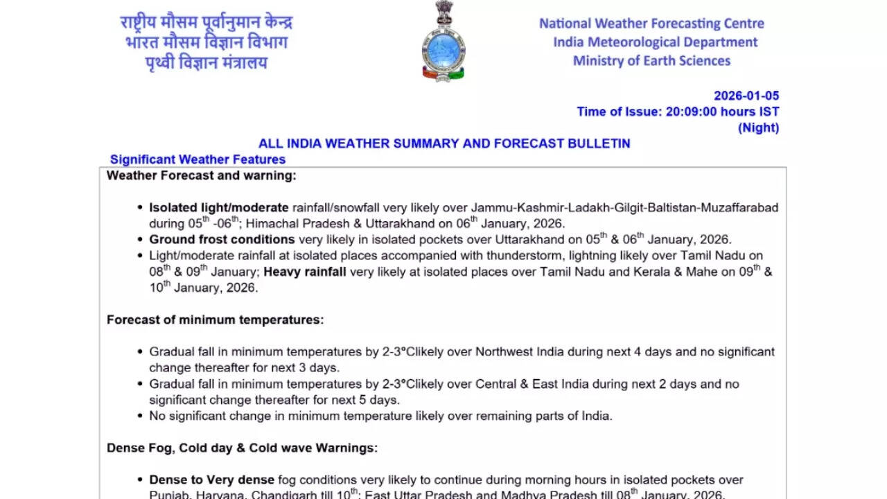
Large parts of the country are set to experience a prolonged spell of harsh winter weather from January 6 onwards, with the India Meteorological Department (IMD) warning of cold wave conditions, cold days, dense to very dense fog, and heavy rainfall across several regions. According to the All India Weather Summary and Forecast Bulletin issued on January 5, 2026, the next several days are likely to remain challenging, particularly for northern, central and eastern India, while southern states brace for intense rainfall and thunderstorms.
Widespread cold wave conditions in North and Central India
From January 6, cold wave conditions are expected to prevail at isolated places over Punjab, Haryana, Chandigarh, Delhi, Rajasthan, Chhattisgarh and Jharkhand. The situation is likely to remain severe over the following days, with cold wave conditions continuing over Punjab, Haryana, Chandigarh and Rajasthan till at least January 9, and extending over east Rajasthan till January 10.

IMD weather report
In addition to cold waves, cold day conditions are also likely to affect several regions. On January 6, cold day conditions are very likely in isolated pockets of Bihar, Madhya Pradesh, sub-Himalayan West Bengal and Sikkim, Gangetic West Bengal and western Rajasthan. These conditions are expected to persist over parts of Rajasthan and sub-Himalayan West Bengal and Sikkim on January 7 as well.The IMD has also indicated that minimum temperatures across northwest India are likely to fall gradually by 2 to 3 degrees Celsius over the next four days, from January 6 to January 9. A similar drop is expected over central and eastern India during January 6 and 7. No significant change in minimum temperatures is forecast thereafter, suggesting a sustained cold spell rather than a brief dip.
Dense to very dense fog to disrupt morning hours
One of the most widespread impacts of the prevailing weather pattern will be dense to very dense fog during morning hours across several states. From January 6, dense to very dense fog is very likely in isolated pockets over Punjab, Haryana, Chandigarh, eastern Uttar Pradesh and Madhya Pradesh. These conditions are expected to persist till January 8 or beyond in many regions, with Punjab, Haryana and Chandigarh likely to witness very dense fog till January 10.Dense fog is also forecast over Uttarakhand, Rajasthan, Himachal Pradesh, western Uttar Pradesh and eastern Uttar Pradesh over varying periods extending up to January 12 in some areas. Eastern and northeastern states are not spared either, with dense fog likely over Bihar till January 12, Assam and Meghalaya till January 10, and Nagaland, Manipur, Mizoram and Tripura till January 10.On January 6 alone, dense fog is very likely in isolated pockets over Assam and Meghalaya, Bihar, Chhattisgarh, Himachal Pradesh, Jharkhand, Odisha, Rajasthan, Uttarakhand, West Bengal and Sikkim, and West Uttar Pradesh. Dense to very dense fog is also expected over eastern Uttar Pradesh, Haryana, Chandigarh, Madhya Pradesh and Punjab, potentially impacting road, rail and air travel during early morning hours.Adding to the winter hazards, ground frost is very likely to occur in isolated pockets of Uttarakhand on January 6.
Rain and snowfall over the western Himalayas
The western Himalayan region is expected to witness isolated light to moderate rainfall and snowfall on January 6. Himachal Pradesh and Uttarakhand, are also likely to receive precipitation during this period. The IMD has indicated that isolated rainfall activity may continue over the western Himalayan region during the subsequent three days as well. Such weather conditions may lead to temporary disruptions in higher-altitude areas, including road blockages due to snowfall and reduced visibility.
Heavy rainfall and thunderstorms in southern India
While northern India grapples with cold and fog, southern states are preparing for a spell of heavy rainfall. The IMD has forecast light to moderate rainfall at isolated places over Tamil Nadu on January 8 and 9, accompanied by thunderstorms and lightning. More intense weather is expected from January 9 onwards, with heavy rainfall very likely at isolated places over Tamil Nadu, Puducherry, Karaikal, Kerala and Mahe on January 9 and 10.Thunderstorms with lightning are also likely at isolated places over Tamil Nadu, Puducherry and Karaikal on January 8 and 9. The rainfall activity is expected to extend over Kerala, Tamil Nadu, Lakshadweep and the Nicobar Islands during the January 6–8 period.
Squally winds over coastal and open sea areas
The bulletin also warns of squally weather over several sea regions, posing risks to maritime activities. On January 6, squally winds with speeds of 35 to 45 kmph, gusting up to 55 kmph, are likely along and off the Sri Lanka coast, over many parts of the southwest and southeast Bay of Bengal, the Gulf of Mannar and adjoining Comorin area. Despite these conditions, no fishermen warnings have been issued for January 10 and 11, suggesting a possible improvement in marine conditions after January 9.


